
Hurricane Isaías: heavy rain and gusts up to 70 km/h in northern Quintana Roo on October 8
Mexico's weather service expects 50–75 mm of rain and 1–2 meter waves along the Quintana Roo coast as the storm moves away to the northeast.
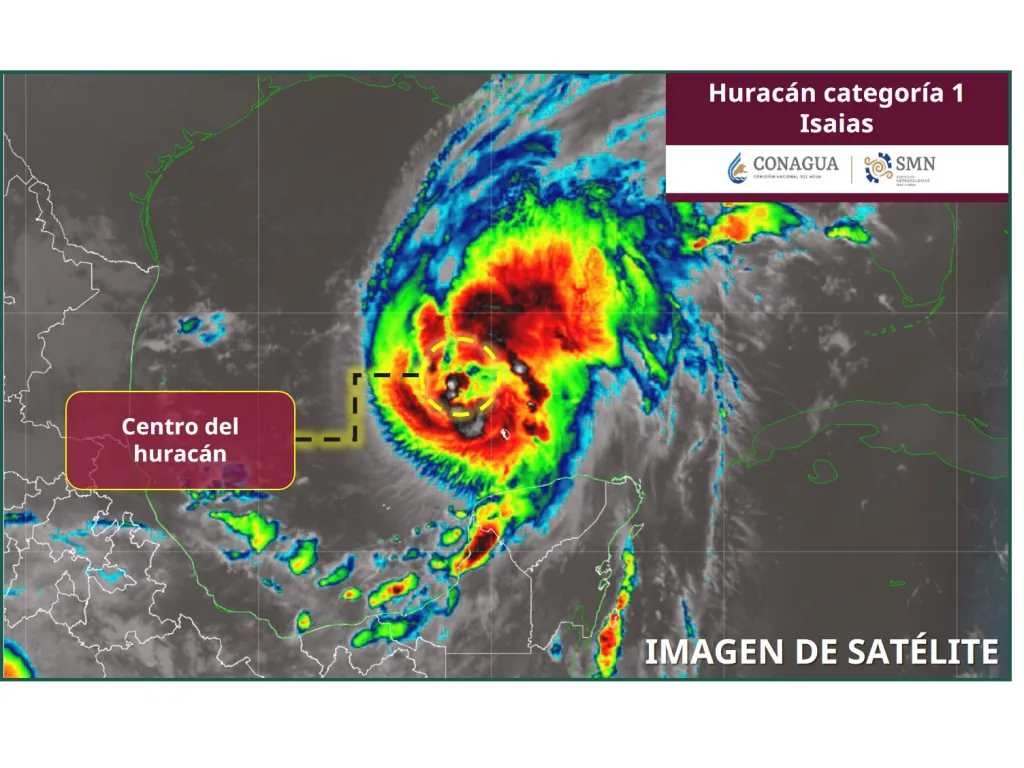
Category 1 Hurricane Isaías will keep bringing heavy rain to northern Quintana Roo, including Cancún, on Thursday, October 8, 2026, according to advisory No. 15 from Mexico's National Meteorological Service (SMN), issued at 6:00 a.m. central time.
Per the SMN, the center of the system was about 280 kilometers north-northwest of Progreso, Yucatán, with sustained winds of 130 km/h and gusts of 160 km/h. It is moving east-northeast at 15 km/h, away from the peninsula across the Gulf of Mexico.
What to expect in Cancún and the north of the state
Although the hurricane's center will not make landfall in Quintana Roo, its broad circulation will still be felt. The SMN forecasts:
- Heavy rain of 50 to 75 millimeters in northern Quintana Roo.
- Winds of 30 to 40 km/h with gusts of 50 to 70 km/h along the coasts of Yucatán and Quintana Roo.
- Waves of 1 to 2 meters along the Quintana Roo coastline (2 to 3 meters in Campeche and Yucatán).
The agency expects Isaías could strengthen to Category 2 before weakening to a tropical storm over the United States around October 10.
What to do today
Rainfall of this size often floods avenues and neighborhoods in Cancún where storm drainage is limited. These basic steps help reduce risk:
- Do not cross flooded streets on foot or by car; you can't tell how deep the water is or whether manholes are open.
- Secure loose items on rooftops, balconies and patios (planters, empty water tanks, metal sheets) that gusts could lift.
- Clear drains and gutters in front of your home so water can flow.
- If you head to the beach, follow the lifeguard flags: waves up to 2 meters increase rip currents.
- If you plan to sail or take a ferry, check with the operator first, since port authorities may restrict small-craft navigation.
- Keep a flashlight, charged batteries and bottled water handy in case of power or water outages.
In an emergency, call 911. Follow official updates from the SMN and Quintana Roo Civil Protection, which are refreshed every few hours.
Related
COEPROC coordinated the army, Conagua, CFE and firefighters over three days; storm drains are being cleared in Chetumal.
Benito Juárez city hall keeps crews on the streets and expects intermittent showers with lightning. Here is how to report flooding and stay safe.
Tropical Wave 42 and a cyclonic circulation keep the state under a forecast of storms with lightning, according to Mexico's National Weather Service.
After an average of 89 millimeters of rain, the city deployed 30 crews and closed several flooded intersections; residents are asked to use alternate routes and clear storm drains.